A Brief Introduction of Himachal Pradesh
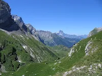
Himachal Pradesh is laterally means Land of Snowy Mountain. Himachal Pradesh is a small world in itself. Himachal Pradesh is also known as Dev Bhoomi or Adobe of Gods, The Fruit bowl of India. Himachal Pradesh is bordered by Jammu and Kashmir on the North, Punjab on the West, Uttar Pradesh on the South and Uttarkhand on the East. Himachal Pradesh which sprawls in the North Western lap of the Himalayas. To the ancients, Himachal was known as the Himalayas itself, with Nepal, Koormachal Kedar, Jalandara and Kashmir as its five natural divisions.
1. Outer Himalaya
or Shivaliks Hills or The Lower Hills: 350 m to 1500 m The outer Himalaya comprises the district of Kangra, Hamirpur,
Una, Bilaspur and lower parts of Mandi, Solan, and Sirmaur are known as
Shivalik Hills. The annual
rainfall in this zone varies from 1500 mm to 1800 mm. In ancient times
the Shivalik Hills were known as Mainak Parbat which laterally means “”tresses
of Shiva”. The famous places in this zone are Paonta valley, Nahan tehsil,
Pacchad and Renuka tehsils of sirmaur, Balh valley, Joginder Nagar, Kangra,
Palampur, Dalhosie, Bhattiyat, Churah
and Chamba. This area is suitable for the cultivation of maize, paddy, wheat, ginger,
sugarcane, table potatoes and citrus fruits.
2. Inner Himalaya or Mid Himalayan Zone: 1500 m to 4500 above sea level, in this zone fall areas like
the upper areas of tehsils of Pachhad
and Renunka in district Sirmaur, Chachiot and Karsog tehsil of Mandi district,
upper parts of Kangra and Palampur, upper Shimla hills and upper parts of
Churah of Chamba district. This
zone comprises two mountain range Pir Panjal and Dhauladhar.
Dhauladhar
means the white peak. Dhauladhar is also known as maulak Parvat. It is the
outermost portion of the Lesser Himalayas. It branches off from the Great
Himalayan range near Badrinath in Uttrakhand
Himachal Pradesh is laterally means Land of Snowy Mountain. Himachal Pradesh is a small world in itself. Himachal Pradesh is also known as Dev Bhoomi or Adobe of Gods, The Fruit bowl of India. Himachal Pradesh is bordered by Jammu and Kashmir on the North, Punjab on the West, Uttar Pradesh on the South and Uttarkhand on the East. Himachal Pradesh which sprawls in the North Western lap of the Himalayas. To the ancients, Himachal was known as the Himalayas itself, with Nepal, Koormachal Kedar, Jalandara and Kashmir as its five natural divisions.
Himachal is bounded between 30°22’ to 33°12’ North latitude and 75°47’ to
79°4’ East longitude. Himachal Pradesh is mountainous with altitude varying
from 350 to 7000 meters above the mean sea level. The total geographical area
of Himachal Pradesh is 55,673 Sq Km. According to the census 2011, the total
population is 68, 64,602. Population wise it is placed 22nd among 29
states. Himachal Pradesh is divided into three zones.
 |
| Shivalik Hills |
 |
| Pir Panjal |
Pir
Panjal is falls mainly in Chamba District. It is the largest range in the
lesser or Inner Himalayas. The largest of the lesser Himalayan ranges the Pir Panjal separates from the greater
Himmalayan range near the bank of Satluj, forming the watter divide between the
Chenab on the one side and the Beas and the Ravi on the other.
 |
| Dhauladhar Hills |
The
variety of soil found in these areas ranges from silty loam to clay loam of dark brown in colour, which is useful for seed potatoes
and temperature fruits. This type of soil is found in Pacchad, Renuka Arki,
solan, Joginder Nagar, Palampur, Kangra, Dalhousie and Churah.
The
soil of upper parts of Shimla, Sirmaur and
Chamba is shallower in depth, but
silty loam to loam of dark brown in colour. From the horticultural point of
view, this area is most useful for stone and soft fruits grown.
 |
| Zanskar Hills |
3. Alpine Zone or
The greater Himalayas: 4500 m to 7000 m,
to the north of the Pir Panjal and Dhauladhar ranges the more high mountain
ranges, known as The Great Himalayan and
Zanskar ranges. The Great Himalayan range runs along the eastern boundary and
is cut across by the Satluj. It comprises Kinnaur district, Pangi of Chamba
district and some areas of Lahaul & Spitti. This is useful for the
cultivation of dry fruits. Snowfall starts
in the mid of October to March-April. Shilla (7026m) the highest
mountain peak in the state lies in the Zanskar range in Kinnaur District.
Physiographically,
the state can be divided into five zones.
- Wet Sub temperature zone comprising of Palampur and Dharamshala areas of Kangra district, Joginder Nagar of Mandi district and Dalhousie area of Chamba district
- Humid sub temperature: comprising of Kullu and Shimla districts and parts of Mandi, Solan, Chamba, Kangra and Sirmaur Districts.
- Dry temperature: alpine high lands which include major parts of Lahaul Spitti, Pangi and Kinnaur.
- Humid Sub Tropical zone: Containing the Bilaspur, major parts of Mandi district, Nahan area of Sirmaur district, Bhattiyat valley of Chamba district, Nalagarh of Solan district and Dehra and Nurpur areas of Kangra district
- Sub humid tropical zone: comprising Una district, Poanta Sahib area of Sirmaur district and Indora area of Kangra district.

No comments:
Post a Comment